Neighbourhoods Listings Why West Kelowna
Learn
WFN Leasehold Zoning Guide Strata Complexes Investors Calculators Quiz History Blog Our Team Contact Free Evaluation
About & History

Not one neighbourhood: several pockets along one road.

Officially named "Westside Road/Bear Creek Road" by the City of West Kelowna, this corridor is nothing like the suburban grid neighbourhoods further south. It's made up of several distinct pockets, Traders Cove, Wilson's Landing, Fintry, and Killiney Beach, strung along the winding shoreline. Expect a mix of high-end lakeshore estates with private docks, rustic cabins, modular lakefront communities, and acreage properties nestled against the mountains, for a peaceful, rural, retreat-style lifestyle centred on the water and pine forests.

Lower Westside Road (near Traders Cove) is just 8-12 minutes from the Bennett Bridge and downtown Kelowna. The farther-north pockets, Fintry and Killiney Beach, take roughly 25-40 minutes, trading convenience for genuine remote tranquility.

Bear Creek Provincial Park sits right at the start of the corridor. Established in 1981 and expanded to its current 178 hectares (440 acres) in 1988, it's long been one of the more heavily used regional parks in the Okanagan (BC Parks recorded roughly 240,000 visits in a 2017–18 reporting period; current figures should be confirmed with BC Parks directly). Farther north, Fintry Provincial Park protects the heritage Fintry Estate and packing house, with trails leading up a dramatic waterfall stair climb and a boat launch.
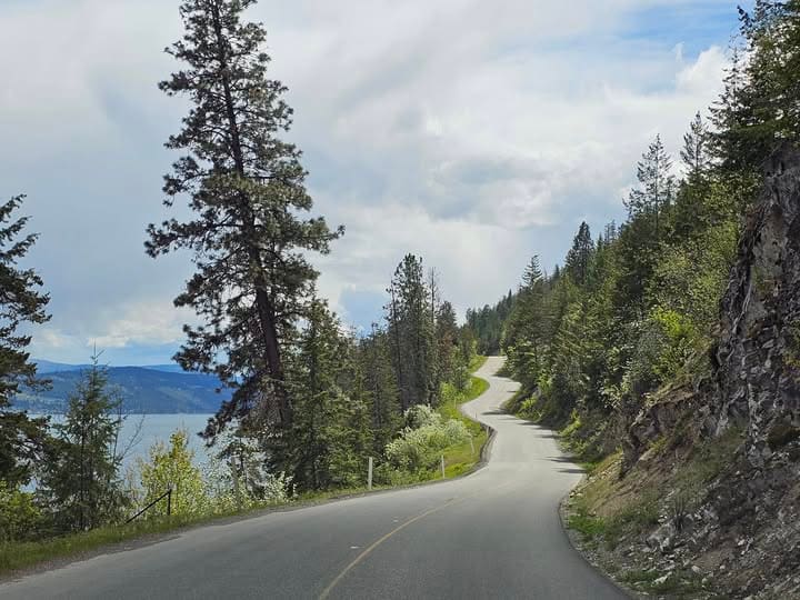
Okanagan Lake shoreline near Westside Road
Lakeside beach near Bear Creek Provincial Park
Location & Geography

The northernmost neighbourhood, west of Highway 97.

Westside Road is the northernmost of West Kelowna's seven neighbourhoods, the last stop heading north from Glenrosa (the southernmost) through Smith Creek, Shannon Lake, and West Kelowna Estates. Unlike those more built-up pockets, Westside Road is defined by its length along the lakeshore, running north out of the main built-up area of the city toward Fintry.

There are no major grocery stores or pharmacies directly along the road itself. Residents drive into West Kelowna Estates, Westbank Centre, or across to Kelowna for standard errands. That's part of the trade-off for direct lakeshore and park-adjacent living.

What's Nearby

Bear Creek Provincial Park

The defining amenity right at the start of the corridor.

0 ac
Park Size (178 hectares)
0m+
Beach Length
0km
Marked Hiking Trails
0
Campsites at Peak Season

Established in 1981 and expanded to its current size in 1988, Bear Creek is managed by BC Parks and offers lakeside camping, picnic areas, and trails that loop around the creek and surrounding canyon.

Schools

No school directly on the corridor.

Because the corridor is rural and spread out, students commute by school bus to nearby catchments in Central Okanagan School District #23: Mar Jok Elementary (K–5, the main primary school for lower Westside Road), Hudson Road Elementary (K–5, French Immersion), Constable Neil Bruce Middle (6–8), and Mount Boucherie Secondary (9–12).

More Along the Corridor

Parks, backcountry & the drive itself

Beach Pockets

Traders Cove & Raymer Bay

Quiet beach access, grassy picnic grounds, and swimming areas along the lake.

Off-Roading

Bear Creek OHV Site

In the mountains directly behind Westside Road, hundreds of km of designated trails for dirt biking, ATVing, and off-roading.

The Drive

Narrow & Winding

Westside Road is famously narrow and cliffside in stretches. Road improvements have helped, but winter driving in dark, icy, or stormy conditions requires extra care.

Homes along the mountain slope sit in a dense forest interface, so FireSmart principles, property clearance, and wildfire evacuation awareness are essential parts of living here.

Active Listings

Homes for sale along Westside Road

Updated daily, straight from MLS®.

–
Loading listings...
Strata Living

Strata development in Westside Road

A gated bare-land strata estate-lot community here, with its own page and live MLS® listings.

See All Researched Complexes →
Common Questions

Westside Road FAQ

A beach over 400 metres long, about 5 km of hiking trails looping a creek and canyon, and lakeside camping with 145 campsites at peak season. It's one of the more visited regional parks in the Okanagan.

It's further out than the city's more central neighbourhoods. Westside Road runs north along the lakeshore toward Fintry, so the drive back to Westbank Centre and Highway 97C is longer than from a more central neighbourhood like Lakeview Heights.

The City of West Kelowna names it as a single combined area: "Westside Road/Bear Creek Road," the northernmost of the city's seven neighbourhoods, west of Highway 97.

Free & No Obligation

What's your Westside Road property worth?

Get a straight read from a team that tracks this neighbourhood closely.

✓
Message Sent
We'll follow up within one business day. For the fastest reply, feel free to call or text 250-861-6002 or email info@markjontz.com directly.
Something went wrong. Please call 250-861-6002.